***
Since we are here in Wellington, New Zealand and our experiences may come in handy to those coming over, I have decided to share some of these and labeled under "NZ Tip". However, circumstances may change and so I advise my readers to take things with a grain of salt.
One of the main concerns we had when we were planning our move was our choice of suburb in relation to the distance we have to travel in order to go to the city proper (more popularly known as the CBD: Central Business District). We were actually assuming before that it will be quite expensive if we live in the city itself. We eventually found out we were wrong, as attested by the rates we were able to find in Trademe. You can get good rates on apartments, especially single bedroom units. Understandably, these will be smaller than those found in the neighboring areas but you can save up on bus fares which is considerable. A zone 3 roundtrip from Newlands to the CBD via the Newlands Coach, for example, will cost NZ$8.00 or roughly PhP200.00! Imagine if you need to go to the city on a daily basis and you need to take the bus; this will really drain up your reserves. But I'm veering off to the topic on hand... so going back:
One main concern we had was, where can we find places for rent, and how can we determine how far is it from the city? Not really measured by distance but by time. If you do not know anybody living in Wellington, then researching this can be quite a challenge.
Here's the simplest way to do this.
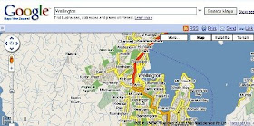
Visit Google maps at http://maps.google.co.nz/ and search for "Wellington". This will show you the districts in and around the CBD. Use this as your guide in familiarizing yourself with the area.

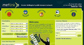
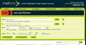
Open another browser window and visit Metlink (http://www.metlink.org.nz). Metlink provides very useful information on travel times via bus, train, ferry, cable car. At the right side of the screen is the "Journey Planner". Let us, for example, find out how to get to the city from Johnsonville. We then type in "Johnsonville" in the From field, then "Central Business District" in the To field. Click the Go button.

In the next window, type in the time when you will either leave, or should be in your destination, as well as the date. I have indicated 7:30AM (this system uses military time), with the default modes of transportation as is. Click on the "Plan Journey" button.

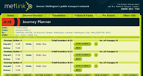
You will then be given suggestions on your To and From entries as compared to its database. Usually, when you write a district's name, the system will give you the area's busiest place, which would usually be the rows of shops, the main street, or mall. For the "central business district', the system gave me 26 Brandon Street which, when checked in Google Maps, is located within the CBD itself so this should give me a good idea of my itinerary. Click on the "Plan Journey" button once again.
You will then be given three options to travel based on various times. But even from this page, I can already see that it will take me at least 21 minutes to travel to the city by bus if I were to live in Johnsonville, and that I do not have to switch buses on this trip (changes: 0). Clicking on the "view journey" button per option will give you more detail on where you would be waiting for your bus, waiting time, and even approximate walking time.

If you put in exact addresses in the fields, the times indicated will be even more accurate.

Great Tip nick. Ganun pala yun. cool! :)
ReplyDeleteLeo: Kelan ka pupunta dito?
ReplyDelete